How to encode coordinate reference system definitions. Builds on referenceSystems.xsd to encode the data needed to define
coordinate reference systems, including the specific subtypes of coordinate reference systems.
This schema encodes the Coordinate Reference System (SC_) package of the extended UML Model for OGC Abstract Specification
Topic 2: Spatial Referencing by Coordinates, with the exception of the abstract "SC_CRS" class. The "SC_CRS" class is encoded
in referenceSystems.xsd, to eliminate the (circular) references from coordinateOperations.xsd to coordinateReferenceSystems.xsd.
That UML model is adapted from ISO 19111 - Spatial referencing by coordinates, as described in Annex C of Topic 2.
Caution: The CRS package in GML 3.1 and GML 3.1.1 is preliminary, and is expected to undergo some modifications that are
not backward compatible during the development of GML 3.2 (ISO 19136). The GML 3.2 package will implement the model described
in the revised version of ISO 19111.
GML is an OGC Standard.
Copyright (c) 2001,2005,2010 Open Geospatial Consortium.
To obtain additional rights of use, visit http://www.opengeospatial.org/legal/ .
Properties
attribute form default:
unqualified
element form default:
qualified
version:
3.1.1.2
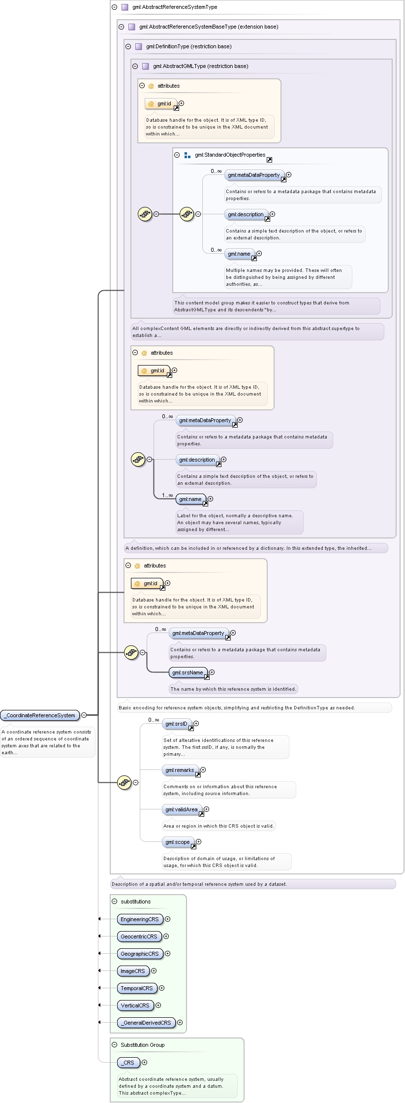
Element gml:_CoordinateReferenceSystem
Namespace
http://www.opengis.net/gml
Annotations
A coordinate reference system consists of an ordered sequence of coordinate system axes that are related to the earth through
a datum. A coordinate reference system is defined by one datum and by one coordinate system. Most coordinate reference system
do not move relative to the earth, except for engineering coordinate reference systems defined on moving platforms such as
cars, ships, aircraft, and spacecraft. For further information, see OGC Abstract Specification Topic 2.
Coordinate reference systems are commonly divided into sub-types. The common classification criterion for sub-typing of coordinate
reference systems is the way in which they deal with earth curvature. This has a direct effect on the portion of the earth's
surface that can be covered by that type of CRS with an acceptable degree of error. The exception to the rule is the subtype
"Temporal" which has been added by analogy.
Database handle for the object. It is of XML type ID, so is constrained to be unique in the XML document within which it
occurs. An external identifier for the object in the form of a URI may be constructed using standard XML and XPointer methods.
This is done by concatenating the URI for the document, a fragment separator, and the value of the id attribute.
Source
<element name="_CoordinateReferenceSystem" type="gml:AbstractReferenceSystemType" abstract="true" substitutionGroup="gml:_CRS"><annotation><documentation>A coordinate reference system consists of an ordered sequence of coordinate system axes that are related to the earth through a datum. A coordinate reference system is defined by one datum and by one coordinate system. Most coordinate reference system do not move relative to the earth, except for engineering coordinate reference systems defined on moving platforms such as cars, ships, aircraft, and spacecraft. For further information, see OGC Abstract Specification Topic 2.
Coordinate reference systems are commonly divided into sub-types. The common classification criterion for sub-typing of coordinate reference systems is the way in which they deal with earth curvature. This has a direct effect on the portion of the earth's surface that can be covered by that type of CRS with an acceptable degree of error. The exception to the rule is the subtype "Temporal" which has been added by analogy.</documentation></annotation></element>
Reference to an XML Schema fragment that specifies the content model of the propertys value. This is in conformance with the
XML Schema Section 4.14 Referencing Schemas from Elsewhere.
Database handle for the object. It is of XML type ID, so is constrained to be unique in the XML document within which it
occurs. An external identifier for the object in the form of a URI may be constructed using standard XML and XPointer methods.
This is done by concatenating the URI for the document, a fragment separator, and the value of the id attribute.
Reference to an XML Schema fragment that specifies the content model of the propertys value. This is in conformance with the
XML Schema Section 4.14 Referencing Schemas from Elsewhere.
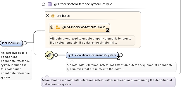
<element name="includesCRS" type="gml:CoordinateReferenceSystemRefType"><annotation><documentation>An association to a component coordinate reference system included in this compound coordinate reference system.</documentation></annotation></element>
Reference to an XML Schema fragment that specifies the content model of the propertys value. This is in conformance with the
XML Schema Section 4.14 Referencing Schemas from Elsewhere.
Database handle for the object. It is of XML type ID, so is constrained to be unique in the XML document within which it
occurs. An external identifier for the object in the form of a URI may be constructed using standard XML and XPointer methods.
This is done by concatenating the URI for the document, a fragment separator, and the value of the id attribute.
Reference to an XML Schema fragment that specifies the content model of the propertys value. This is in conformance with the
XML Schema Section 4.14 Referencing Schemas from Elsewhere.
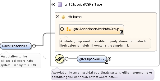
<element name="usesEllipsoidalCS" type="gml:EllipsoidalCSRefType"><annotation><documentation>Association to the ellipsoidal coordinate system used by this CRS.</documentation></annotation></element>
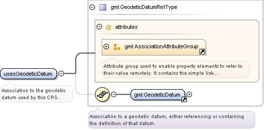
Element gml:usesGeodeticDatum
Namespace
http://www.opengis.net/gml
Annotations
Association to the geodetic datum used by this CRS.
Reference to an XML Schema fragment that specifies the content model of the propertys value. This is in conformance with the
XML Schema Section 4.14 Referencing Schemas from Elsewhere.
<element name="usesGeodeticDatum" type="gml:GeodeticDatumRefType"><annotation><documentation>Association to the geodetic datum used by this CRS.</documentation></annotation></element>
Reference to an XML Schema fragment that specifies the content model of the propertys value. This is in conformance with the
XML Schema Section 4.14 Referencing Schemas from Elsewhere.
Database handle for the object. It is of XML type ID, so is constrained to be unique in the XML document within which it
occurs. An external identifier for the object in the form of a URI may be constructed using standard XML and XPointer methods.
This is done by concatenating the URI for the document, a fragment separator, and the value of the id attribute.
Reference to an XML Schema fragment that specifies the content model of the propertys value. This is in conformance with the
XML Schema Section 4.14 Referencing Schemas from Elsewhere.
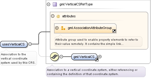
<element name="usesVerticalCS" type="gml:VerticalCSRefType"><annotation><documentation>Association to the vertical coordinate system used by this CRS.</documentation></annotation></element>
Element gml:usesVerticalDatum
Namespace
http://www.opengis.net/gml
Annotations
Association to the vertical datum used by this CRS.
Reference to an XML Schema fragment that specifies the content model of the propertys value. This is in conformance with the
XML Schema Section 4.14 Referencing Schemas from Elsewhere.
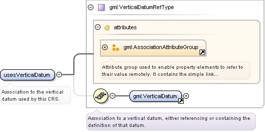
<element name="usesVerticalDatum" type="gml:VerticalDatumRefType"><annotation><documentation>Association to the vertical datum used by this CRS.</documentation></annotation></element>
Reference to an XML Schema fragment that specifies the content model of the propertys value. This is in conformance with the
XML Schema Section 4.14 Referencing Schemas from Elsewhere.
Database handle for the object. It is of XML type ID, so is constrained to be unique in the XML document within which it
occurs. An external identifier for the object in the form of a URI may be constructed using standard XML and XPointer methods.
This is done by concatenating the URI for the document, a fragment separator, and the value of the id attribute.
Reference to an XML Schema fragment that specifies the content model of the propertys value. This is in conformance with the
XML Schema Section 4.14 Referencing Schemas from Elsewhere.
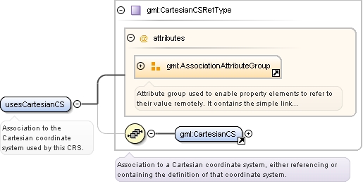
<element name="usesCartesianCS" type="gml:CartesianCSRefType"><annotation><documentation>Association to the Cartesian coordinate system used by this CRS.</documentation></annotation></element>
Element gml:usesSphericalCS
Namespace
http://www.opengis.net/gml
Annotations
Association to the spherical coordinate system used by this CRS.
Reference to an XML Schema fragment that specifies the content model of the propertys value. This is in conformance with the
XML Schema Section 4.14 Referencing Schemas from Elsewhere.
<element name="usesSphericalCS" type="gml:SphericalCSRefType"><annotation><documentation>Association to the spherical coordinate system used by this CRS.</documentation></annotation></element>
Reference to an XML Schema fragment that specifies the content model of the propertys value. This is in conformance with the
XML Schema Section 4.14 Referencing Schemas from Elsewhere.
Database handle for the object. It is of XML type ID, so is constrained to be unique in the XML document within which it
occurs. An external identifier for the object in the form of a URI may be constructed using standard XML and XPointer methods.
This is done by concatenating the URI for the document, a fragment separator, and the value of the id attribute.
Reference to an XML Schema fragment that specifies the content model of the propertys value. This is in conformance with the
XML Schema Section 4.14 Referencing Schemas from Elsewhere.
<element name="baseCRS" type="gml:CoordinateReferenceSystemRefType"><annotation><documentation>Association to the coordinate reference system used by this derived CRS.</documentation></annotation></element>
Element gml:definedByConversion
Namespace
http://www.opengis.net/gml
Annotations
Association to the coordinate conversion used to define this derived CRS.
Reference to an XML Schema fragment that specifies the content model of the propertys value. This is in conformance with the
XML Schema Section 4.14 Referencing Schemas from Elsewhere.
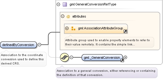
<element name="definedByConversion" type="gml:GeneralConversionRefType"><annotation><documentation>Association to the coordinate conversion used to define this derived CRS.</documentation></annotation></element>
Database handle for the object. It is of XML type ID, so is constrained to be unique in the XML document within which it
occurs. An external identifier for the object in the form of a URI may be constructed using standard XML and XPointer methods.
This is done by concatenating the URI for the document, a fragment separator, and the value of the id attribute.
Reference to an XML Schema fragment that specifies the content model of the propertys value. This is in conformance with the
XML Schema Section 4.14 Referencing Schemas from Elsewhere.
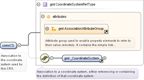
<element name="usesCS" type="gml:CoordinateSystemRefType"><annotation><documentation>Association to the coordinate system used by this CRS.</documentation></annotation></element>
Reference to an XML Schema fragment that specifies the content model of the propertys value. This is in conformance with the
XML Schema Section 4.14 Referencing Schemas from Elsewhere.
Database handle for the object. It is of XML type ID, so is constrained to be unique in the XML document within which it
occurs. An external identifier for the object in the form of a URI may be constructed using standard XML and XPointer methods.
This is done by concatenating the URI for the document, a fragment separator, and the value of the id attribute.
Reference to an XML Schema fragment that specifies the content model of the propertys value. This is in conformance with the
XML Schema Section 4.14 Referencing Schemas from Elsewhere.
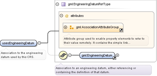
<element name="usesEngineeringDatum" type="gml:EngineeringDatumRefType"><annotation><documentation>Association to the engineering datum used by this CRS.</documentation></annotation></element>
Reference to an XML Schema fragment that specifies the content model of the propertys value. This is in conformance with the
XML Schema Section 4.14 Referencing Schemas from Elsewhere.
Database handle for the object. It is of XML type ID, so is constrained to be unique in the XML document within which it
occurs. An external identifier for the object in the form of a URI may be constructed using standard XML and XPointer methods.
This is done by concatenating the URI for the document, a fragment separator, and the value of the id attribute.
Reference to an XML Schema fragment that specifies the content model of the propertys value. This is in conformance with the
XML Schema Section 4.14 Referencing Schemas from Elsewhere.
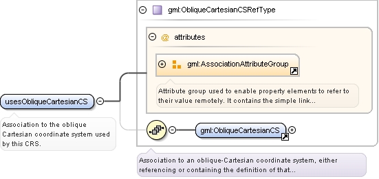
<element name="usesObliqueCartesianCS" type="gml:ObliqueCartesianCSRefType"><annotation><documentation>Association to the oblique Cartesian coordinate system used by this CRS.</documentation></annotation></element>
Reference to an XML Schema fragment that specifies the content model of the propertys value. This is in conformance with the
XML Schema Section 4.14 Referencing Schemas from Elsewhere.
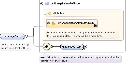
<element name="usesImageDatum" type="gml:ImageDatumRefType"><annotation><documentation>Association to the image datum used by this CRS.</documentation></annotation></element>
Reference to an XML Schema fragment that specifies the content model of the propertys value. This is in conformance with the
XML Schema Section 4.14 Referencing Schemas from Elsewhere.
Database handle for the object. It is of XML type ID, so is constrained to be unique in the XML document within which it
occurs. An external identifier for the object in the form of a URI may be constructed using standard XML and XPointer methods.
This is done by concatenating the URI for the document, a fragment separator, and the value of the id attribute.
Reference to an XML Schema fragment that specifies the content model of the propertys value. This is in conformance with the
XML Schema Section 4.14 Referencing Schemas from Elsewhere.
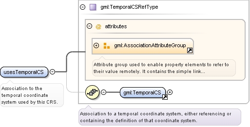
<element name="usesTemporalCS" type="gml:TemporalCSRefType"><annotation><documentation>Association to the temporal coordinate system used by this CRS.</documentation></annotation></element>
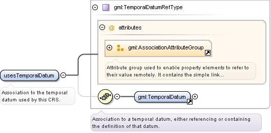
Element gml:usesTemporalDatum
Namespace
http://www.opengis.net/gml
Annotations
Association to the temporal datum used by this CRS.
Reference to an XML Schema fragment that specifies the content model of the propertys value. This is in conformance with the
XML Schema Section 4.14 Referencing Schemas from Elsewhere.
<element name="usesTemporalDatum" type="gml:TemporalDatumRefType"><annotation><documentation>Association to the temporal datum used by this CRS.</documentation></annotation></element>
Reference to an XML Schema fragment that specifies the content model of the propertys value. This is in conformance with the
XML Schema Section 4.14 Referencing Schemas from Elsewhere.
Reference to an XML Schema fragment that specifies the content model of the propertys value. This is in conformance with the
XML Schema Section 4.14 Referencing Schemas from Elsewhere.
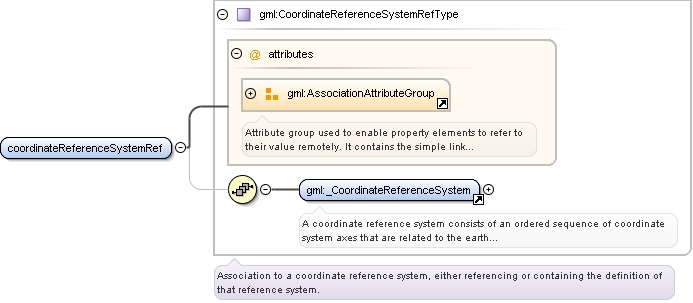
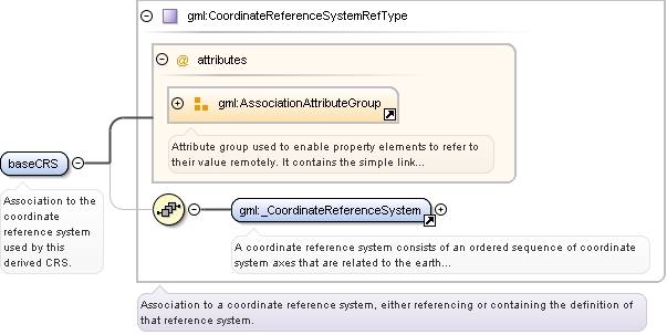
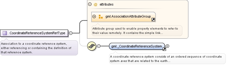
<complexType name="CoordinateReferenceSystemRefType"><annotation><documentation>Association to a coordinate reference system, either referencing or containing the definition of that reference system.</documentation></annotation><sequence minOccurs="0"><element ref="gml:_CoordinateReferenceSystem"/></sequence><attributeGroup ref="gml:AssociationAttributeGroup"/></complexType>
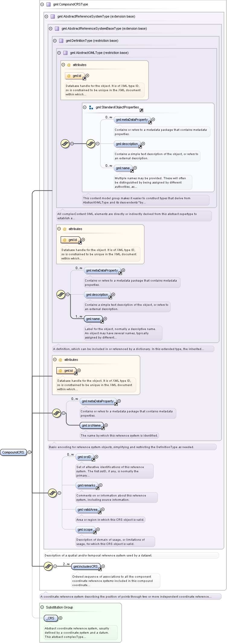
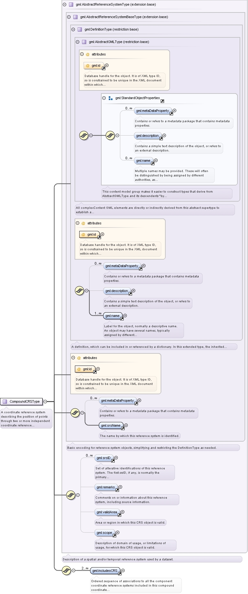
Complex Type gml:CompoundCRSType
Namespace
http://www.opengis.net/gml
Annotations
A coordinate reference system describing the position of points through two or more independent coordinate reference systems.
Database handle for the object. It is of XML type ID, so is constrained to be unique in the XML document within which it
occurs. An external identifier for the object in the form of a URI may be constructed using standard XML and XPointer methods.
This is done by concatenating the URI for the document, a fragment separator, and the value of the id attribute.
Source
<complexType name="CompoundCRSType"><annotation><documentation>A coordinate reference system describing the position of points through two or more independent coordinate reference systems.</documentation></annotation><complexContent><extension base="gml:AbstractReferenceSystemType"><sequence><element ref="gml:includesCRS" minOccurs="2" maxOccurs="unbounded"><annotation><documentation>Ordered sequence of associations to all the component coordinate reference systems included in this compound coordinate reference system.</documentation></annotation></element></sequence></extension></complexContent></complexType>
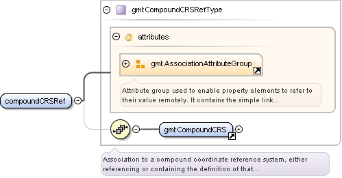
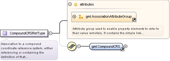
Complex Type gml:CompoundCRSRefType
Namespace
http://www.opengis.net/gml
Annotations
Association to a compound coordinate reference system, either referencing or containing the definition of that reference system.
Reference to an XML Schema fragment that specifies the content model of the propertys value. This is in conformance with the
XML Schema Section 4.14 Referencing Schemas from Elsewhere.
<complexType name="CompoundCRSRefType"><annotation><documentation>Association to a compound coordinate reference system, either referencing or containing the definition of that reference system.</documentation></annotation><sequence minOccurs="0"><element ref="gml:CompoundCRS"/></sequence><attributeGroup ref="gml:AssociationAttributeGroup"/></complexType>
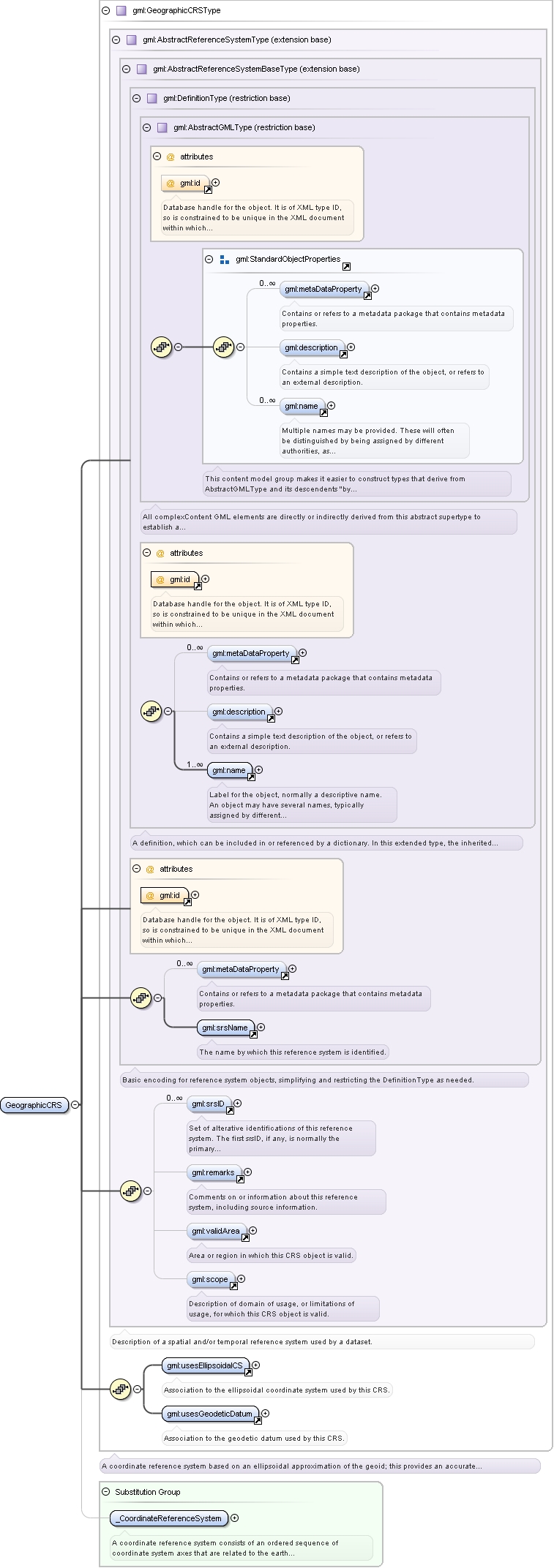
Complex Type gml:GeographicCRSType
Namespace
http://www.opengis.net/gml
Annotations
A coordinate reference system based on an ellipsoidal approximation of the geoid; this provides an accurate representation
of the geometry of geographic features for a large portion of the earth's surface.
Database handle for the object. It is of XML type ID, so is constrained to be unique in the XML document within which it
occurs. An external identifier for the object in the form of a URI may be constructed using standard XML and XPointer methods.
This is done by concatenating the URI for the document, a fragment separator, and the value of the id attribute.
Source
<complexType name="GeographicCRSType"><annotation><documentation>A coordinate reference system based on an ellipsoidal approximation of the geoid; this provides an accurate representation of the geometry of geographic features for a large portion of the earth's surface.</documentation></annotation><complexContent><extension base="gml:AbstractReferenceSystemType"><sequence><element ref="gml:usesEllipsoidalCS"/><element ref="gml:usesGeodeticDatum"/></sequence></extension></complexContent></complexType>
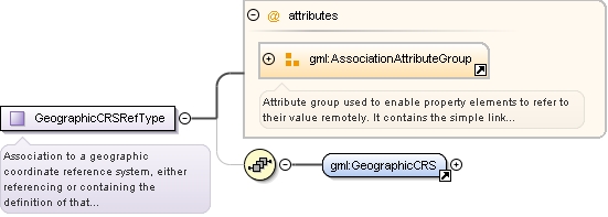
Complex Type gml:GeographicCRSRefType
Namespace
http://www.opengis.net/gml
Annotations
Association to a geographic coordinate reference system, either referencing or containing the definition of that reference
system.
Reference to an XML Schema fragment that specifies the content model of the propertys value. This is in conformance with the
XML Schema Section 4.14 Referencing Schemas from Elsewhere.
<complexType name="GeographicCRSRefType"><annotation><documentation>Association to a geographic coordinate reference system, either referencing or containing the definition of that reference system.</documentation></annotation><sequence minOccurs="0"><element ref="gml:GeographicCRS"/></sequence><attributeGroup ref="gml:AssociationAttributeGroup"/></complexType>
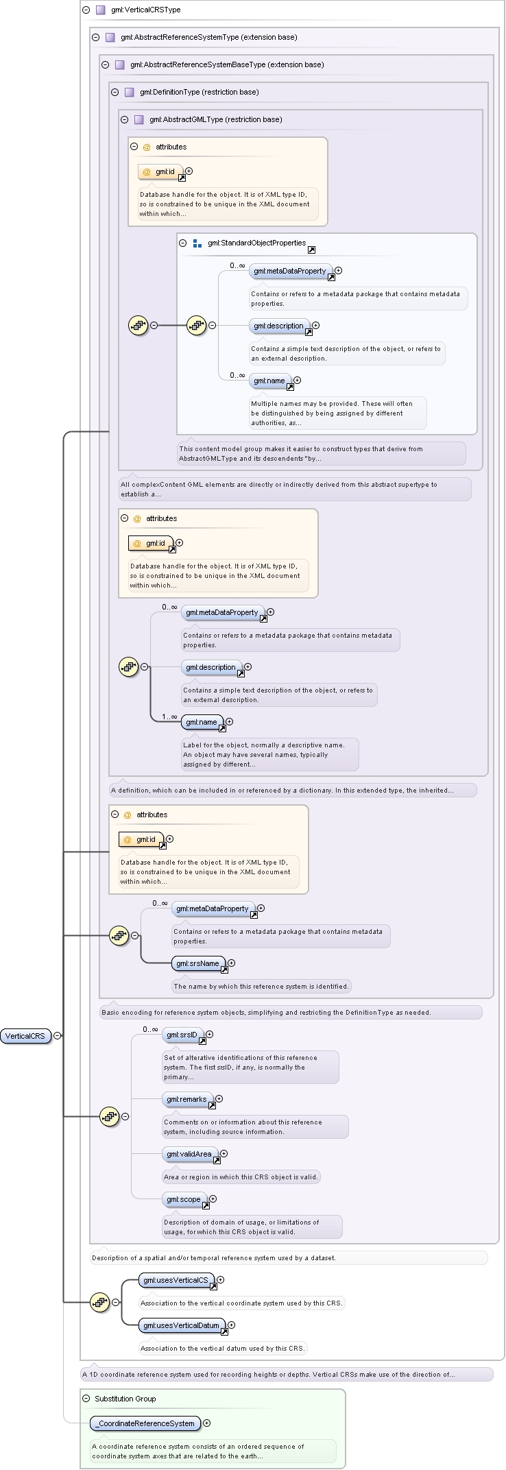
Complex Type gml:VerticalCRSType
Namespace
http://www.opengis.net/gml
Annotations
A 1D coordinate reference system used for recording heights or depths. Vertical CRSs make use of the direction of gravity
to define the concept of height or depth, but the relationship with gravity may not be straightforward. By implication, ellipsoidal
heights (h) cannot be captured in a vertical coordinate reference system. Ellipsoidal heights cannot exist independently,
but only as an inseparable part of a 3D coordinate tuple defined in a geographic 3D coordinate reference system.
Database handle for the object. It is of XML type ID, so is constrained to be unique in the XML document within which it
occurs. An external identifier for the object in the form of a URI may be constructed using standard XML and XPointer methods.
This is done by concatenating the URI for the document, a fragment separator, and the value of the id attribute.
Source
<complexType name="VerticalCRSType"><annotation><documentation>A 1D coordinate reference system used for recording heights or depths. Vertical CRSs make use of the direction of gravity to define the concept of height or depth, but the relationship with gravity may not be straightforward. By implication, ellipsoidal heights (h) cannot be captured in a vertical coordinate reference system. Ellipsoidal heights cannot exist independently, but only as an inseparable part of a 3D coordinate tuple defined in a geographic 3D coordinate reference system.</documentation></annotation><complexContent><extension base="gml:AbstractReferenceSystemType"><sequence><element ref="gml:usesVerticalCS"/><element ref="gml:usesVerticalDatum"/></sequence></extension></complexContent></complexType>
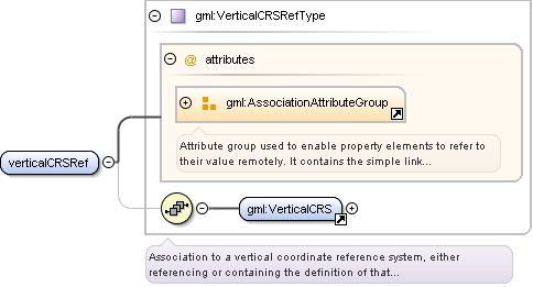
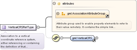
Complex Type gml:VerticalCRSRefType
Namespace
http://www.opengis.net/gml
Annotations
Association to a vertical coordinate reference system, either referencing or containing the definition of that reference system.
Reference to an XML Schema fragment that specifies the content model of the propertys value. This is in conformance with the
XML Schema Section 4.14 Referencing Schemas from Elsewhere.
<complexType name="VerticalCRSRefType"><annotation><documentation>Association to a vertical coordinate reference system, either referencing or containing the definition of that reference system.</documentation></annotation><sequence minOccurs="0"><element ref="gml:VerticalCRS"/></sequence><attributeGroup ref="gml:AssociationAttributeGroup"/></complexType>
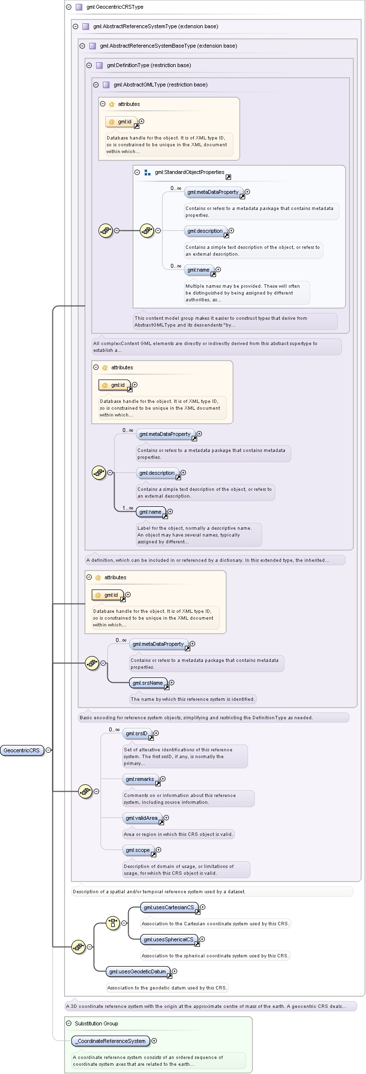
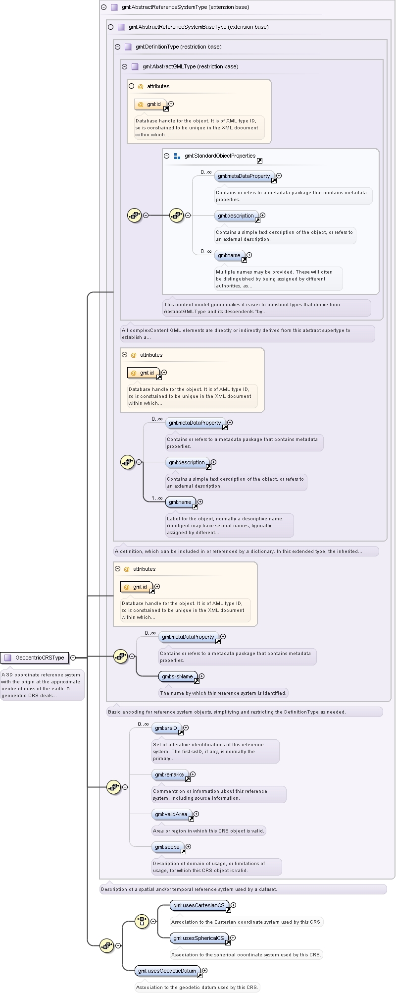
Complex Type gml:GeocentricCRSType
Namespace
http://www.opengis.net/gml
Annotations
A 3D coordinate reference system with the origin at the approximate centre of mass of the earth. A geocentric CRS deals with
the earth's curvature by taking a 3D spatial view, which obviates the need to model the earth's curvature.
Database handle for the object. It is of XML type ID, so is constrained to be unique in the XML document within which it
occurs. An external identifier for the object in the form of a URI may be constructed using standard XML and XPointer methods.
This is done by concatenating the URI for the document, a fragment separator, and the value of the id attribute.
Source
<complexType name="GeocentricCRSType"><annotation><documentation>A 3D coordinate reference system with the origin at the approximate centre of mass of the earth. A geocentric CRS deals with the earth's curvature by taking a 3D spatial view, which obviates the need to model the earth's curvature.</documentation></annotation><complexContent><extension base="gml:AbstractReferenceSystemType"><sequence><choice><element ref="gml:usesCartesianCS"/><element ref="gml:usesSphericalCS"/></choice><element ref="gml:usesGeodeticDatum"/></sequence></extension></complexContent></complexType>
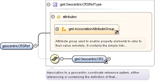
Complex Type gml:GeocentricCRSRefType
Namespace
http://www.opengis.net/gml
Annotations
Association to a geocentric coordinate reference system, either referencing or containing the definition of that reference
system.
Reference to an XML Schema fragment that specifies the content model of the propertys value. This is in conformance with the
XML Schema Section 4.14 Referencing Schemas from Elsewhere.
<complexType name="GeocentricCRSRefType"><annotation><documentation>Association to a geocentric coordinate reference system, either referencing or containing the definition of that reference system.</documentation></annotation><sequence minOccurs="0"><element ref="gml:GeocentricCRS"/></sequence><attributeGroup ref="gml:AssociationAttributeGroup"/></complexType>
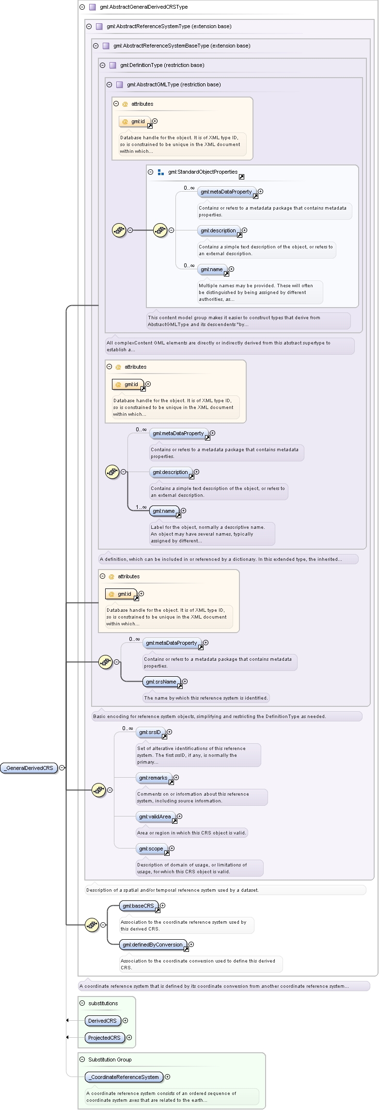
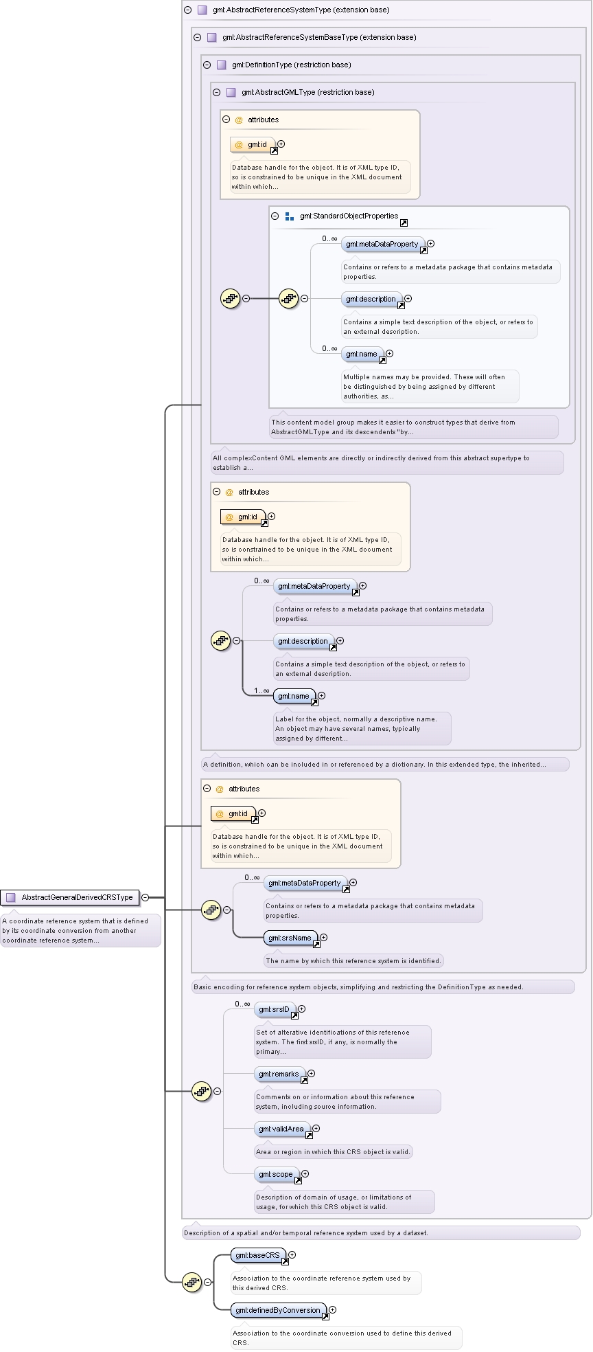
Complex Type gml:AbstractGeneralDerivedCRSType
Namespace
http://www.opengis.net/gml
Annotations
A coordinate reference system that is defined by its coordinate conversion from another coordinate reference system (not by
a datum). This abstract complexType shall not be used, extended, or restricted, in an Application Schema, to define a concrete
subtype with a meaning equivalent to a concrete subtype specified in this document.
Database handle for the object. It is of XML type ID, so is constrained to be unique in the XML document within which it
occurs. An external identifier for the object in the form of a URI may be constructed using standard XML and XPointer methods.
This is done by concatenating the URI for the document, a fragment separator, and the value of the id attribute.
Source
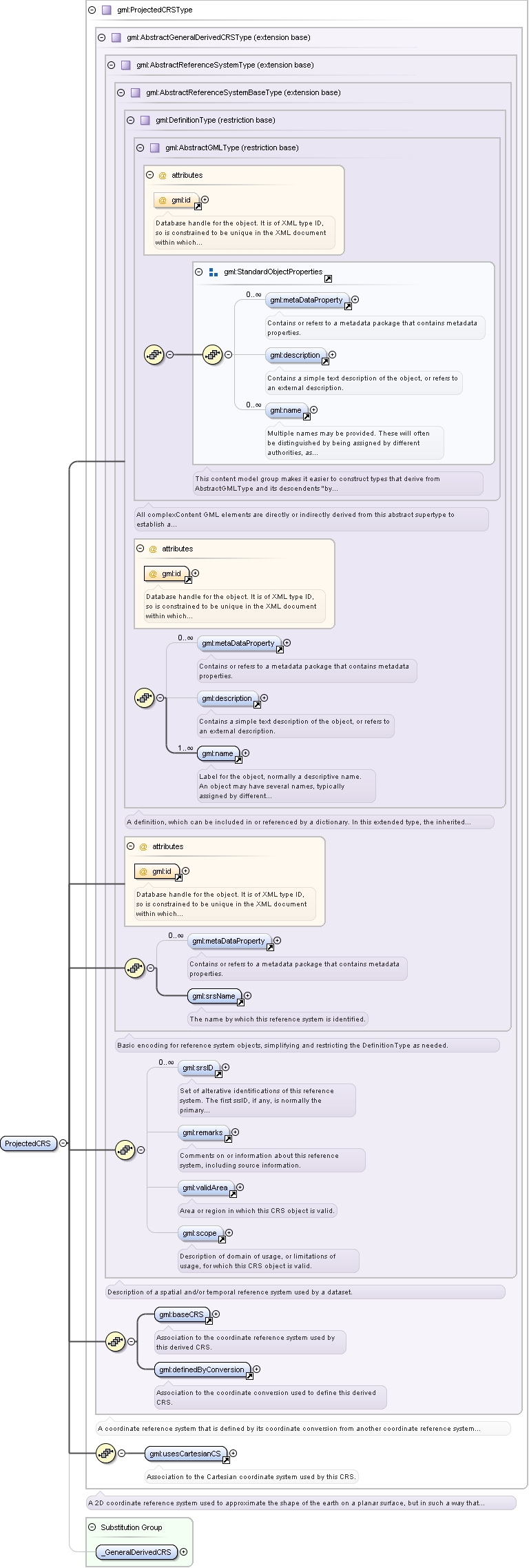
<complexType name="AbstractGeneralDerivedCRSType" abstract="true"><annotation><documentation>A coordinate reference system that is defined by its coordinate conversion from another coordinate reference system (not by a datum). This abstract complexType shall not be used, extended, or restricted, in an Application Schema, to define a concrete subtype with a meaning equivalent to a concrete subtype specified in this document.</documentation></annotation><complexContent><extension base="gml:AbstractReferenceSystemType"><sequence><element ref="gml:baseCRS"/><element ref="gml:definedByConversion"/></sequence></extension></complexContent></complexType>
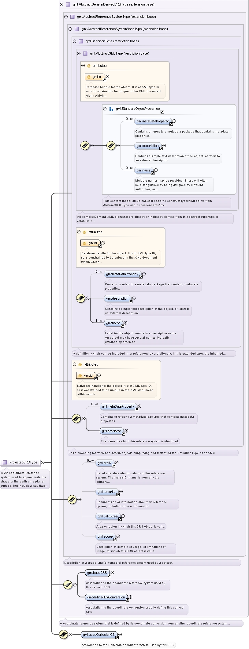
Complex Type gml:ProjectedCRSType
Namespace
http://www.opengis.net/gml
Annotations
A 2D coordinate reference system used to approximate the shape of the earth on a planar surface, but in such a way that the
distortion that is inherent to the approximation is carefully controlled and known. Distortion correction is commonly applied
to calculated bearings and distances to produce values that are a close match to actual field values.
Database handle for the object. It is of XML type ID, so is constrained to be unique in the XML document within which it
occurs. An external identifier for the object in the form of a URI may be constructed using standard XML and XPointer methods.
This is done by concatenating the URI for the document, a fragment separator, and the value of the id attribute.
Source
<complexType name="ProjectedCRSType"><annotation><documentation>A 2D coordinate reference system used to approximate the shape of the earth on a planar surface, but in such a way that the distortion that is inherent to the approximation is carefully controlled and known. Distortion correction is commonly applied to calculated bearings and distances to produce values that are a close match to actual field values.</documentation></annotation><complexContent><extension base="gml:AbstractGeneralDerivedCRSType"><sequence><element ref="gml:usesCartesianCS"/></sequence></extension></complexContent></complexType>
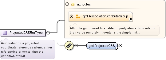
Complex Type gml:ProjectedCRSRefType
Namespace
http://www.opengis.net/gml
Annotations
Association to a projected coordinate reference system, either referencing or containing the definition of that reference
system.
Reference to an XML Schema fragment that specifies the content model of the propertys value. This is in conformance with the
XML Schema Section 4.14 Referencing Schemas from Elsewhere.
<complexType name="ProjectedCRSRefType"><annotation><documentation>Association to a projected coordinate reference system, either referencing or containing the definition of that reference system.</documentation></annotation><sequence minOccurs="0"><element ref="gml:ProjectedCRS"/></sequence><attributeGroup ref="gml:AssociationAttributeGroup"/></complexType>
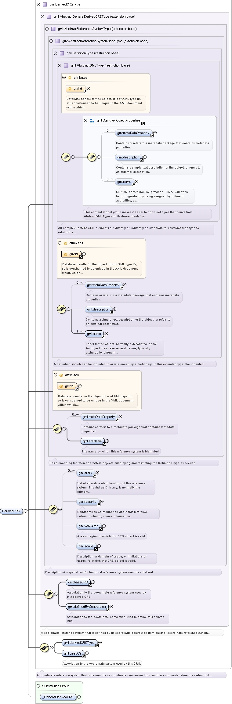
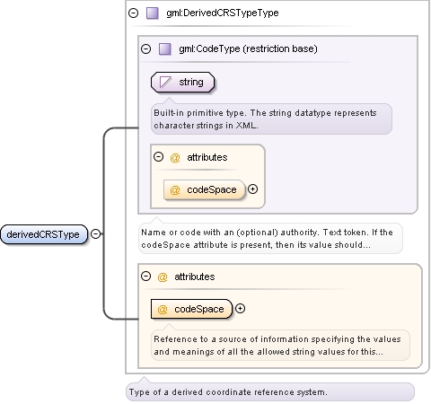
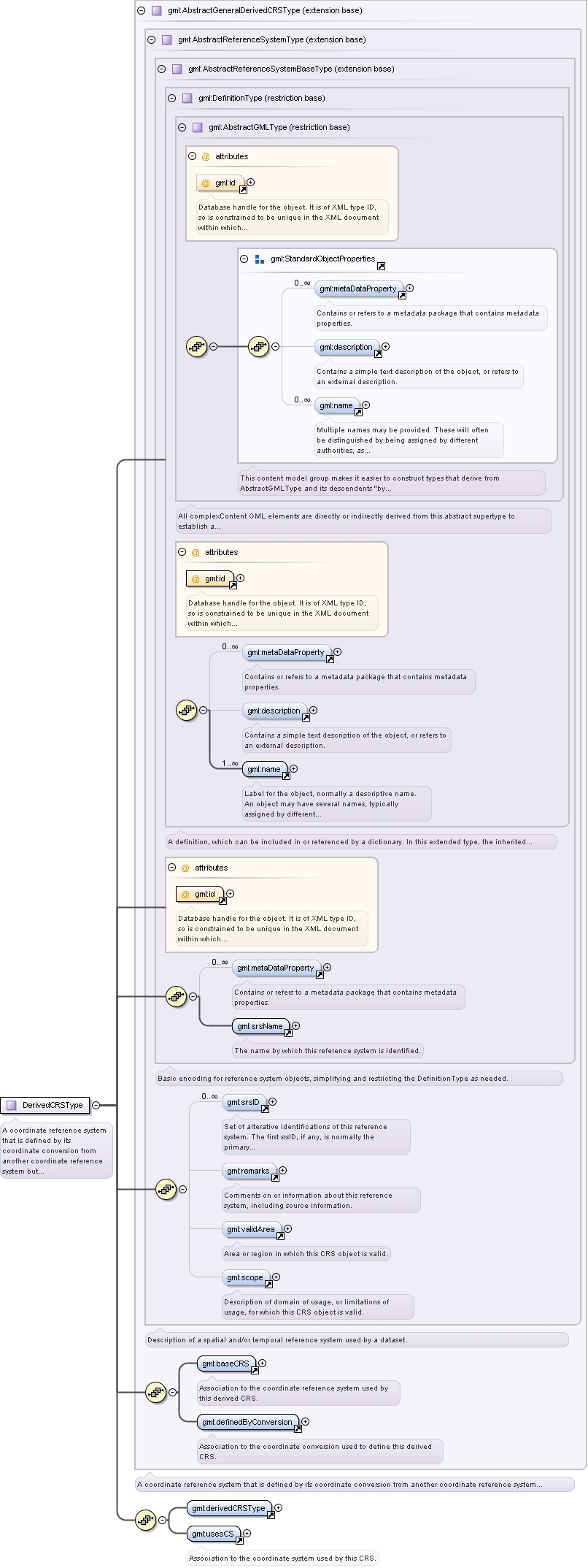
Complex Type gml:DerivedCRSType
Namespace
http://www.opengis.net/gml
Annotations
A coordinate reference system that is defined by its coordinate conversion from another coordinate reference system but is
not a projected coordinate reference system. This category includes coordinate reference systems derived from a projected
coordinate reference system.
Database handle for the object. It is of XML type ID, so is constrained to be unique in the XML document within which it
occurs. An external identifier for the object in the form of a URI may be constructed using standard XML and XPointer methods.
This is done by concatenating the URI for the document, a fragment separator, and the value of the id attribute.
Source
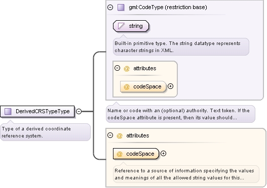
<complexType name="DerivedCRSType"><annotation><documentation>A coordinate reference system that is defined by its coordinate conversion from another coordinate reference system but is not a projected coordinate reference system. This category includes coordinate reference systems derived from a projected coordinate reference system.</documentation></annotation><complexContent><extension base="gml:AbstractGeneralDerivedCRSType"><sequence><element ref="gml:derivedCRSType"/><element ref="gml:usesCS"/></sequence></extension></complexContent></complexType>
Reference to a source of information specifying the values and meanings of all the allowed string values for this DerivedCRSTypeType.
Source
<complexType name="DerivedCRSTypeType"><annotation><documentation>Type of a derived coordinate reference system.</documentation></annotation><simpleContent><restriction base="gml:CodeType"><attribute name="codeSpace" type="anyURI" use="required"><annotation><documentation>Reference to a source of information specifying the values and meanings of all the allowed string values for this DerivedCRSTypeType.</documentation></annotation></attribute></restriction></simpleContent></complexType>
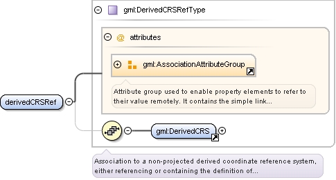
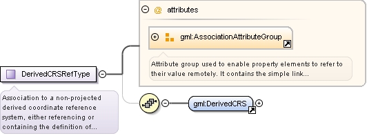
Complex Type gml:DerivedCRSRefType
Namespace
http://www.opengis.net/gml
Annotations
Association to a non-projected derived coordinate reference system, either referencing or containing the definition of that
reference system.
Reference to an XML Schema fragment that specifies the content model of the propertys value. This is in conformance with the
XML Schema Section 4.14 Referencing Schemas from Elsewhere.
<complexType name="DerivedCRSRefType"><annotation><documentation>Association to a non-projected derived coordinate reference system, either referencing or containing the definition of that reference system.</documentation></annotation><sequence minOccurs="0"><element ref="gml:DerivedCRS"/></sequence><attributeGroup ref="gml:AssociationAttributeGroup"/></complexType>
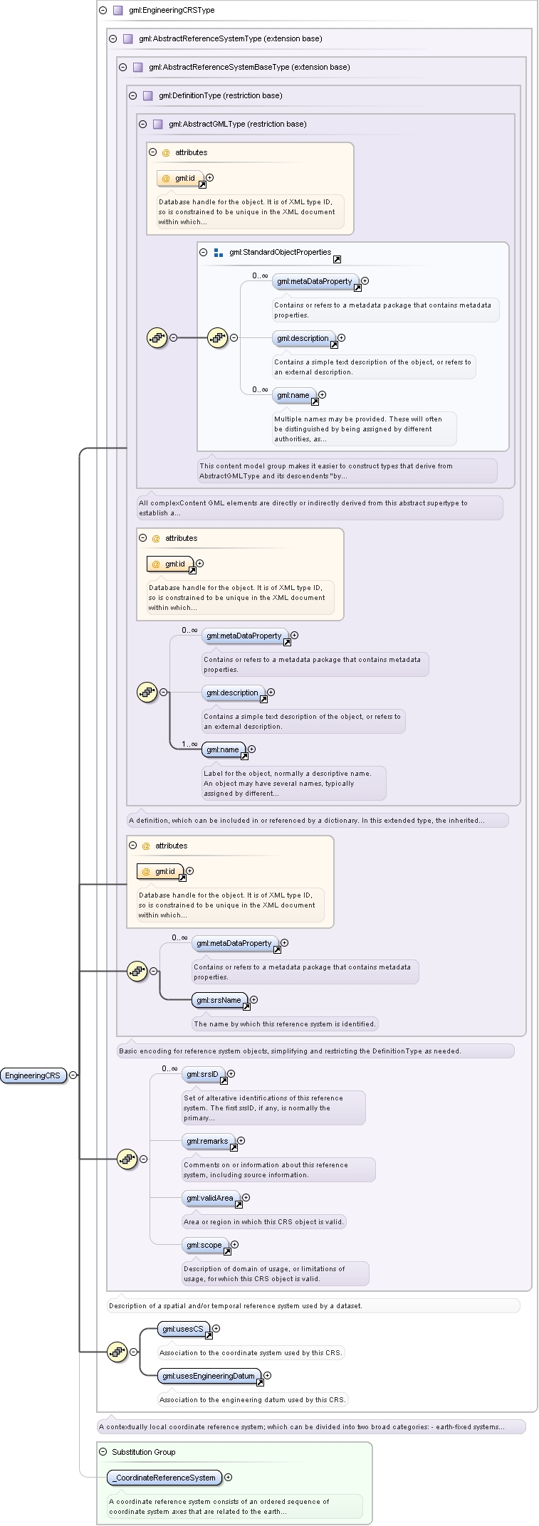
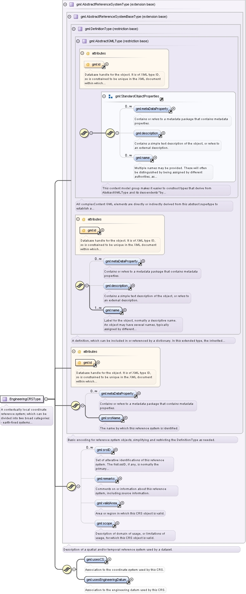
Complex Type gml:EngineeringCRSType
Namespace
http://www.opengis.net/gml
Annotations
A contextually local coordinate reference system; which can be divided into two broad categories:
- earth-fixed systems applied to engineering activities on or near the surface of the earth;
- CRSs on moving platforms such as road vehicles, vessels, aircraft, or spacecraft.
For further information, see OGC Abstract Specification Topic 2.
Database handle for the object. It is of XML type ID, so is constrained to be unique in the XML document within which it
occurs. An external identifier for the object in the form of a URI may be constructed using standard XML and XPointer methods.
This is done by concatenating the URI for the document, a fragment separator, and the value of the id attribute.
Source
<complexType name="EngineeringCRSType"><annotation><documentation>A contextually local coordinate reference system; which can be divided into two broad categories:
- earth-fixed systems applied to engineering activities on or near the surface of the earth;
- CRSs on moving platforms such as road vehicles, vessels, aircraft, or spacecraft.
For further information, see OGC Abstract Specification Topic 2.</documentation></annotation><complexContent><extension base="gml:AbstractReferenceSystemType"><sequence><element ref="gml:usesCS"/><element ref="gml:usesEngineeringDatum"/></sequence></extension></complexContent></complexType>
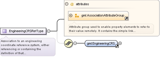
Complex Type gml:EngineeringCRSRefType
Namespace
http://www.opengis.net/gml
Annotations
Association to an engineering coordinate reference system, either referencing or containing the definition of that reference
system.
Reference to an XML Schema fragment that specifies the content model of the propertys value. This is in conformance with the
XML Schema Section 4.14 Referencing Schemas from Elsewhere.
<complexType name="EngineeringCRSRefType"><annotation><documentation>Association to an engineering coordinate reference system, either referencing or containing the definition of that reference system.</documentation></annotation><sequence minOccurs="0"><element ref="gml:EngineeringCRS"/></sequence><attributeGroup ref="gml:AssociationAttributeGroup"/></complexType>
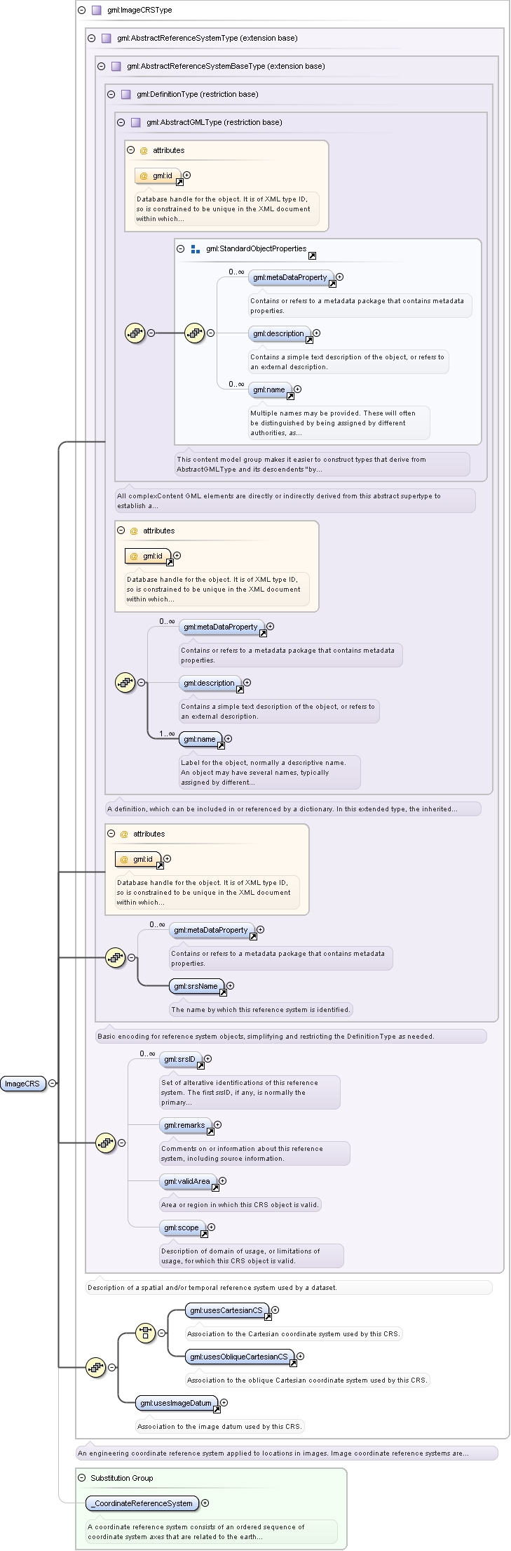
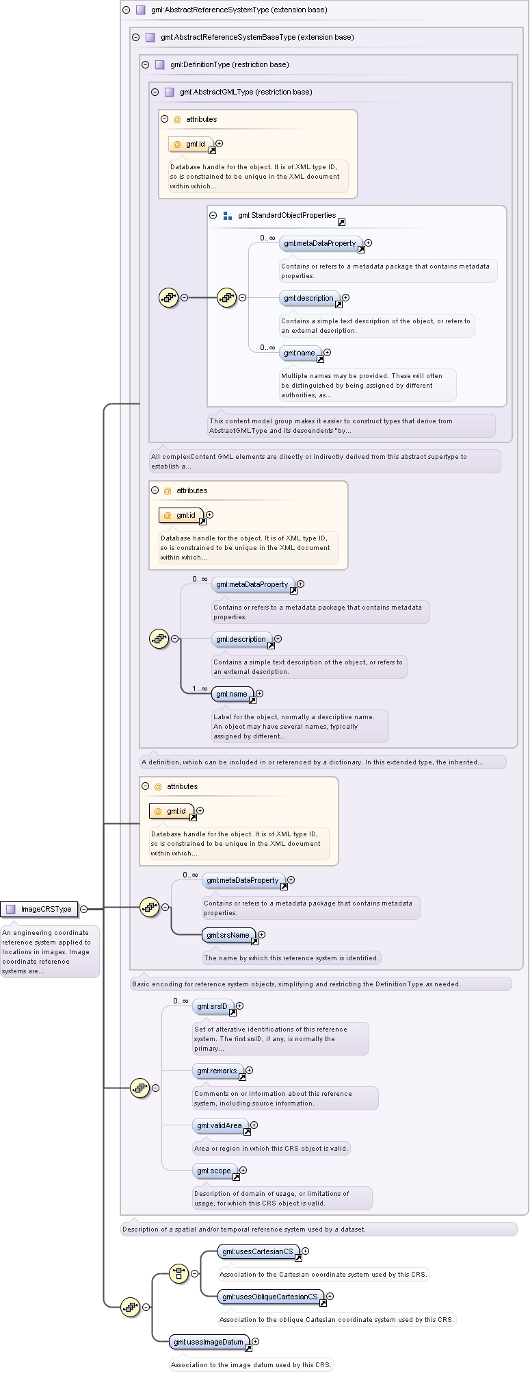
Complex Type gml:ImageCRSType
Namespace
http://www.opengis.net/gml
Annotations
An engineering coordinate reference system applied to locations in images. Image coordinate reference systems are treated
as a separate sub-type because a separate user community exists for images with its own terms of reference.
Database handle for the object. It is of XML type ID, so is constrained to be unique in the XML document within which it
occurs. An external identifier for the object in the form of a URI may be constructed using standard XML and XPointer methods.
This is done by concatenating the URI for the document, a fragment separator, and the value of the id attribute.
Source
<complexType name="ImageCRSType"><annotation><documentation>An engineering coordinate reference system applied to locations in images. Image coordinate reference systems are treated as a separate sub-type because a separate user community exists for images with its own terms of reference.</documentation></annotation><complexContent><extension base="gml:AbstractReferenceSystemType"><sequence><choice><element ref="gml:usesCartesianCS"/><element ref="gml:usesObliqueCartesianCS"/></choice><element ref="gml:usesImageDatum"/></sequence></extension></complexContent></complexType>
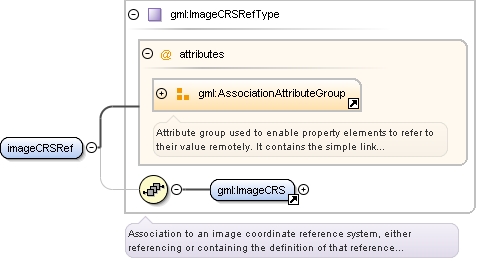
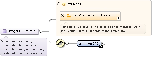
Complex Type gml:ImageCRSRefType
Namespace
http://www.opengis.net/gml
Annotations
Association to an image coordinate reference system, either referencing or containing the definition of that reference system.
Reference to an XML Schema fragment that specifies the content model of the propertys value. This is in conformance with the
XML Schema Section 4.14 Referencing Schemas from Elsewhere.
<complexType name="ImageCRSRefType"><annotation><documentation>Association to an image coordinate reference system, either referencing or containing the definition of that reference system.</documentation></annotation><sequence minOccurs="0"><element ref="gml:ImageCRS"/></sequence><attributeGroup ref="gml:AssociationAttributeGroup"/></complexType>
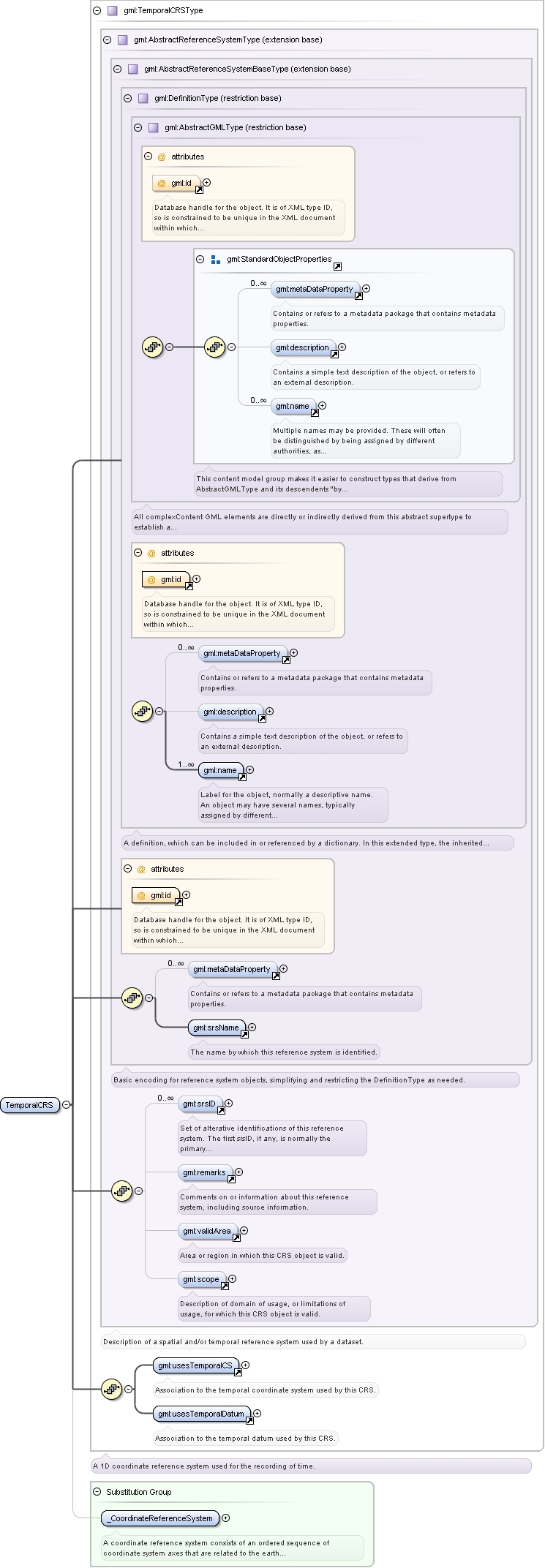
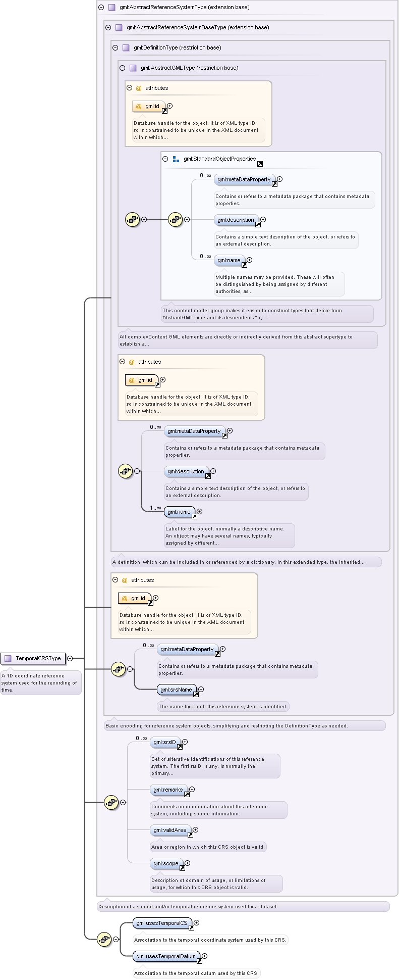
Complex Type gml:TemporalCRSType
Namespace
http://www.opengis.net/gml
Annotations
A 1D coordinate reference system used for the recording of time.
Database handle for the object. It is of XML type ID, so is constrained to be unique in the XML document within which it
occurs. An external identifier for the object in the form of a URI may be constructed using standard XML and XPointer methods.
This is done by concatenating the URI for the document, a fragment separator, and the value of the id attribute.
Source
<complexType name="TemporalCRSType"><annotation><documentation>A 1D coordinate reference system used for the recording of time.</documentation></annotation><complexContent><extension base="gml:AbstractReferenceSystemType"><sequence><element ref="gml:usesTemporalCS"/><element ref="gml:usesTemporalDatum"/></sequence></extension></complexContent></complexType>
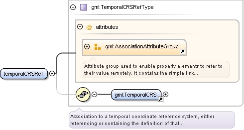
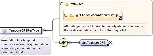
Complex Type gml:TemporalCRSRefType
Namespace
http://www.opengis.net/gml
Annotations
Association to a temporal coordinate reference system, either referencing or containing the definition of that reference system.
Reference to an XML Schema fragment that specifies the content model of the propertys value. This is in conformance with the
XML Schema Section 4.14 Referencing Schemas from Elsewhere.
<complexType name="TemporalCRSRefType"><annotation><documentation>Association to a temporal coordinate reference system, either referencing or containing the definition of that reference system.</documentation></annotation><sequence minOccurs="0"><element ref="gml:TemporalCRS"/></sequence><attributeGroup ref="gml:AssociationAttributeGroup"/></complexType>
<attribute name="codeSpace" type="anyURI" use="required"><annotation><documentation>Reference to a source of information specifying the values and meanings of all the allowed string values for this DerivedCRSTypeType.</documentation></annotation></attribute>